Isoetes melanopoda Gay & Durieu ex Durieu Isoetaceae
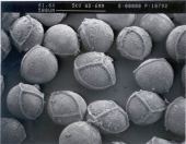
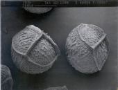
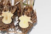
Megaspores. Pearl River Co, Mississippi. Tentative determination.
Megaspores. Dekalb Co, GA.
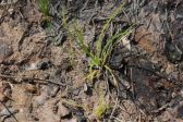
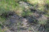
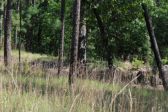
Scrappin Valley Preserve, Jasper County, Texas. 9 May 2018. 31°8.443' North, 93°47.680' West
Habitat. Scrappin Valley Preserve, Jasper County, Texas. 9 May 2018. 31°8.443' North, 93°47.680' West
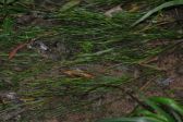
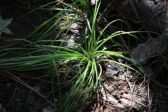
Secondary forest on E side of CR 145, 1 mi. N of US 45 and about 1.75 mi. S of Shubuta, Wayne County, Mississippi. 17 June. Plants in what appear to be vehicle ruts as well as braided stream, now dry. Truncated phyllopodia (shorter than usual) present on all plants examined. This specimen exhibits megaspore polymorphism as well as a branching rhizomorph. Soil is a heavy clay. 31° 50' 16.9" North, 88° 41' 13.5" West (31.838017, -88.687097). With: Peter Schafran
Secondary forest on E side of CR 145, 1 mi. N of US 45 and about 1.75 mi. S of Shubuta, Wayne County, Mississippi. 17 June. Plants in what appear to be vehicle ruts as well as braided stream, now dry. Phyllopodia present on all plants examined. Soil is a heavy clay. 31° 50' 16.9" North, 88° 41' 13.5" West
(31.838017, -88.687097)
Megaspores. Grundy Co, TN.
Habitat. Scrappin Valley Preserve, Jasper County, Texas. 9 May 2018. 31°8.443' North, 93°47.680' West
In seepage along road, with Drosera, Pinquicula, and other wetland plants. Angelina National Forest, Boykin Springs Area, Angelina County, Texas. 8 May 2018. 31°5.058' North, 94°17.310 West.
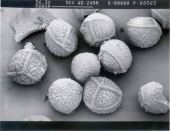
Blue River Wildlife Management Area, Johnston County, Oklahoma. Seepage area along granite outcrop. In shallow pools at base of granite boulders with Ludwigia repens, Ptilimnium nuttallii, Sabatia campestris, Cyperus aristatus, Panicum dichotomofolium. Collected by permit. 28 June 2014. 34°21'46.6" North, 96°35'47.2" West (34.362938, -96.596447). Plants also at 34.36196°N, 96.59431°W.
Blue River Wildlife Management Area, Johnston County, Oklahoma. Seepage area along granite outcrop. In shallow pools at base of granite boulders with Ludwigia repens, Ptilimnium nuttallii, Sabatia campestris, Cyperus aristatus, Panicum dichotomofolium. Collected by permit. 28 June 2014. 34°21'46.6" North, 96°35'47.2" West (34.362938, -96.596447). Plants also at 34.36196°N, 96.59431°W.